The countryside changes, and as soon as a route has been
mapped and a guide produced, changes will occur. Here we will give details
of any changes along the way that have come to our attention. That may be
a new fence and stile, a changed sign, a path diversion or whatever. If
you come across any changes whilst walking A Dales High Way please email
us at the address at the foot of this page, giving as much detail as
possible and attach a photo if possible. Many thanks.
Most recent changes are shown at the top.
Route Guide (3rd Ed.): Pages 21, Section 2, Map 9 "Gordale House to
Kirkby Fell". (1/7/22)
Companion (2nd Ed): Page 43, Section
2, "Gordale House to Kirkby Fell". Para (9).

An update in policy at the Yorkshire Dales National Park
Authority on waymarking along National Trails has meant
the loss of a few Dales High Way waymarks. The policy is intended to
declutter National Trail signage, by restricting the addition of
other waymarks from recognised Recreational Routes to the points
where they "join" and "leave" the National Trail.
In the case of A Dales Hign Way (DHW) this has affected the
section it shares with the Pennine Bridleway (PBW) between Malham and
Settle. A Dales High Way joins the Pennine Bridleway (Settle Loop)
above Langscar Gate. The PBW fingerpost at this point continues to
carry DHW waymarks, but further PBW fingerposts at Nappa Gate and
Stockdale Lane have lost them. The changes have been implemented as
new replacement fingerposts have been installed.
The directions in the Route Guide and Companion
remain, however, quite clear and so should cause walkers no trouble
in route finding.
A Dales High Way is reasonably well,
though minimally, waymarked, in line with advice in "Signs and
Waymarking, Good Practice Guide, The Institute of Public Rights of
Way and Access Management, 2009." which states: " A user not
familiar with the area should be helped to follow the route, but this
does not mean that he should be able to do it with no map and without
thinking”. Good navigational skills and an up-to-date Guide Book and Map are
essential.
Route Guide (3rd Ed.): Page 10, Section 1, Map 1 "Saltaire to
Weecher Reservoir". Top (29/5/21)
Companion (2nd Ed): Page 19, Section
1, "Saltaire to Weecher Reservoir" Para (11).
A potentially dangerous short road section near the start of A
Dales High Way has been made safe, thanks to work by Bradford
Council's Highways department.
The 200 metre road section leads from Weecher Reservoir onto
Bingley Moor. Traffic along this stretch is very fast and the only
verge on one side was difficult on foot due to a drainage ditch.
This has now been stabilised and filled over with gravel, and
bollards have been erected to separate it from the traffic.
This means a much safer passage for walkers. Our thanks must go to Kevin
Whittaker of Bradford Highways in particular for making this happen!

Route Guide (2nd Ed.): Page 26, Section 3, Map 11 "Settle to
Smearset Scar". (22/4/14)
A good deal of new tree planting has been undertaken along the River
Ribble on the approach to Stainforth Force. Some new fencing and gating has
been added, but the route itself remains unchanged. The planting has been
undertaken by the Ribble Trust.

See the Ribble
Trust website here.
Route Guide (1st Ed.): Page 47, Section 5, Map 22B "ALTERNATIVE route from
Gais Gill to Newbiggin-on-Lune". (6/6/12)
Companion: Page 91, Section 5, Part 22B, "Gais Gill to
Ravenstonedale and Newbiggin-on-Lune", Para 3.
A new cycle and walk way alongside the busy A685, opened in March 2012,
has made the quarter mile journey here very much easier and now provides a
pleasant one mile walk between the two villages. This is useful for those
staying in Ravenstonedale and following the main route, and those taking
the ALTERNATIVE bad weather route to the east of the Howgills.
 |
 |
| The new cycle and walk way alongside the busy A685 |
Official opening, March 10 2012 |
Route Guide (1st Ed.): Page 11, Section 1, Map 2 "Weecher Reservoir to
White Wells",
Box 7. (1/11/11)
Companion: Page 22, Section 1, Part 2, "Weecher Reservoir to
White Wells", Para 7.
The Boardwalks across wet areas of Ilkley Moor, descending from Lanshaw
Lad to Ilkley Crags, have now been replaced by flagstones.
|
Flagstones replace boardwalk on Ilkley
Moor |
 |
Route Guide (1st Ed.): Page 19, Section 2, Map 7 "Sharp Haw to Moor Lane (Hetton)",
Box 2. (6/3/11)
Companion: Page 38, Section 2, Part 7, "Sharp Haw to Moor Lane
(Hetton)", Para 2.
The main Bridleway that crosses Flasby Fell has been cleared and marked
with a line of blue-topped posts, to make it easier to follow in summer,
when it is liable to become overgrown with bracken. The alternative routes
above and below remain.
|
Bridleway across Flasby Fell |
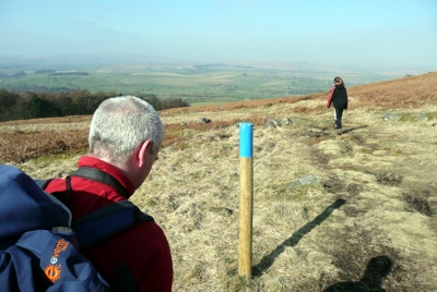 |
Route Guide (1st Ed.): Page 36, Section 3, Map 17 "Wold End to Dent". (21/3/10)
Along the riverside path from Bridge End to Dent, where the route joins
the Dales Way, most of the stiles have now been replaced by
gates.
|
Stile before... |
Gate now... |
 |
 |
Route Guide (1st Ed.): Page 28, Section 3, Map 13 "Crummack to Simon
Fell", Box 3. (9/3/10)
The Access Column referred to, used to carry a sign forbidding vehicles
from venturing further. It is has now been removed
altogether! This is at the point where you climb up above Crummack to
reach the brow of the hill, when Ingleborough comes into full view. There
are no landmark features at this spot now, so care is needed with
navigation.
|
Before |
later... |
Now gone...
|
 |
 |
 |
Route Guide (1st Ed.): Page 26, Section 3, Map 11 "Settle to Smearset
Scar", Box 3. (19/3/09)
The sign near Stackhouse that points down the walled track to the river
weir and used to read FP to Locks has been replaced. It now reads Public
Footpath, Ribble Way, Stainforth.

